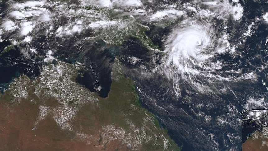

Severe Tropical Cyclone Maila is once again advancing toward Queensland from the Solomon Sea, located approximately 1,300 kilometers off the Australian coastline.
This category four cyclone is currently moving westward at a speed of 7 km/h.
Predictions indicate that Tropical Cyclone Maila will make landfall on the Cape York Peninsula “early next week,” transitioning into a category two system.
After a period of inactivity, Severe Tropical Cyclone Maila is back on the move, having stalled previously in the Solomon Sea.
The Bureau of Meteorology has confirmed that Maila is still expected to reach the Far North Queensland coast on Monday.
Senior meteorologist Liam Smart noted that the category four cyclone is generating wind gusts of up to 260 km/h and had temporarily paused due to a lack of steering winds. “Tropical cyclones require some form of movement assistance,” he explained. “Typically, there are steering winds coming from the east or west, but that was not the case here.”
However, conditions shifted this morning, allowing the cyclone to resume its westward trajectory toward the Coral Sea and Australia at a pace of 7 km/h.
“Currently, we anticipate a category two crossing, but it’s still early in the forecast, and adjustments may be necessary,” he added.
Maila is expected to make landfall “early next week,” potentially impacting areas similar to where Severe Tropical Cyclone Narelle affected less than three weeks ago.
Mr. Smart highlighted that there remains considerable uncertainty regarding the exact location of the cyclone’s landfall.
Meanwhile, much of Queensland is experiencing predominantly sunny weather, with temperatures well above the seasonal average.
The bureau has reported that temperatures are projected to be between 5 and 7 degrees Celsius higher than usual across extensive areas of the central and southern interior.
Today, St George could set a record for maximum April temperatures, with forecasts indicating highs of 37°C, surpassing the existing record of 36.2°C established in 2016.
The Cassowary Coast is expected to be the only area to receive rain in the short term, with light showers anticipated and the possibility of extending south toward the Whitsundays later in the week.
In South East Queensland, temperatures are expected to be 3 to 4 degrees above average today but should decrease as a weak cool front moves through later this week.
The bureau indicated that this trough would have a more pronounced effect in the western regions when it arrives on Saturday, potentially causing temperatures to drop to around 7 degrees below average.
Despite the expected cooler temperatures, the skies across the Darling Downs are likely to remain mostly clear.
Isaac Anderson, a farmer from Greenmount, remarked that conditions are becoming increasingly dry. “We haven’t received nearly as much rain as we did at this time last year,” he noted. “It’s beginning to get a bit dry now.”
Coastal communities are also advised to prepare for rough seas and hazardous surf conditions later in the week, influenced by Severe Tropical Cyclone Vaianu located south of Fiji. “The swell from that system will take time to reach Queensland, but it is expected to arrive around Sunday,” Mr. Smart stated.