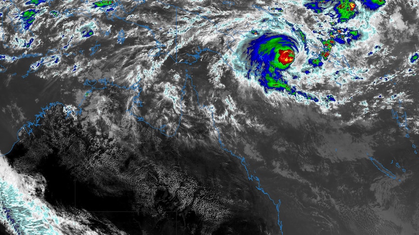

The Bureau of Meteorology has reported that Severe Tropical Cyclone Maila is currently classified as a category three storm and is gradually advancing towards Australian waters.
On the previous day, Queensland experienced temperatures that were 9 degrees Celsius higher than the seasonal average, resulting in multiple April temperature records being surpassed.
Cyclone Maila is projected to make landfall in northern Queensland by Tuesday.
As it continues its westward journey, Cyclone Maila has weakened and slowed down compared to its status from a day earlier.
After being stagnant in the Solomon Sea for several days, the cyclone gained some speed yesterday morning, but has since decelerated again.
On Friday morning, the storm was downgraded from a category four to a category three system.
The Bureau of Meteorology (BOM) indicated that the precise path of Maila remains uncertain; however, predictive models suggest it may cross the Queensland coast north of Cooktown, likely near the Coen and Lockhart River areas, on either Monday or Tuesday.
Currently, Maila is situated between Papua New Guinea and the Solomon Islands and is expected to move past Papua New Guinea over the weekend.
BOM senior forecaster Shane Kennedy described the cyclone’s behavior as “a real tease,” noting that it is expected to diminish in strength as it interacts with land masses in Papua New Guinea and passes over various islands.
Kennedy anticipates that Maila will downgrade to a category two system by the time it nears the Far North Queensland shore next week. He emphasized the importance of monitoring the situation closely in the days leading up to its arrival.
In contrast to Severe Tropical Cyclone Narelle, which impacted Cape York Peninsula on March 20, Senior Meteorologist Angus Hines highlighted that Maila’s movement has exhibited significant differences. He noted that Narelle had clear steering mechanisms, allowing for more accurate predictions of its path.
Conversely, Hines remarked that Maila has been largely stationary for several days, with weak driving forces complicating predictions about its future trajectory and intensity.
As Maila continues to travel over 800 kilometers east of Port Moresby, the weather bureau forecasts that it will likely make landfall near Coen and Lockhart River on Cape York Peninsula.
Lockhart River Mayor Wayne Butcher expressed concern, as the community, located 530 kilometers northwest of Cairns, is still recovering from the effects of Cyclone Narelle. He stated, “We’re not looking forward to it if it’s coming our way,” but reassured that residents have gained valuable experience from past storms.
Mayor Butcher advised residents to secure their properties and ensure that items such as wheelie bins are properly tied down, as several were blown away during the last storm. He also stressed the importance of removing any loose debris that could become hazardous in high winds.
The local disaster management group is scheduled to convene on Friday, with a focus on securing adequate food and fuel supplies for the power station, airport, and the community of 640 residents.
He noted that the Pascoe and Wenlock rivers are currently saturated, and additional heavy rainfall could further isolate the community. “The rivers are still way up, so we can’t drive out of the community at the moment,” he said.
According to Council CEO David Clarke, some residents along the Pascoe River are still relying on campfires for cooking due to damage caused by record flooding from Cyclone Narelle.
Health authorities have issued a warning regarding melioidosis, a potentially fatal disease associated with tropical soil, air, and water. The Cairns Public Health Unit has documented 30 cases this year, with no fatalities, compared to 106 cases and 17 deaths during the same period last year.
Unit director Jacqueline Murdoch cautioned that individuals with weakened immune systems or chronic health conditions are at heightened risk. She advised the public to take precautions, such as wearing boots or gloves while gardening and protecting any cuts or scrapes.
Murdoch also recommended that those in high-risk categories remain indoors during heavy rain periods.
This week, Queensland has experienced several record-breaking temperature highs, with some areas reporting readings 9 degrees Celsius above the April average. For instance, Applethorpe recorded its highest April temperature ever at 31.9 degrees Celsius, while Warwick reached 33.9 degrees Celsius, surpassing its previous record from 2006.
Toowoomba also noted its hottest April day on Wednesday, reaching 31.5 degrees Celsius, breaking the record set in 2020.
The BOM anticipates a sunny and dry day for most of Queensland on Friday, with a slight chance of showers along the north tropical coast. Above-average daytime temperatures are expected to persist until a southerly wind change arrives around Sunday, with maximums projected at 30 degrees Celsius in Brisbane and the Gold Coast, and 29 degrees Celsius on the Sunshine Coast.