
A Chinese firm, MizarVision, has been releasing AI-enhanced satellite imagery of US military installations in the Middle East, which US intelligence officials believe is assisting Iranian forces in identifying strategic targets. This information was relayed to ABC News by a source within the US Department of Defense, who expressed concern that these images pose a significant risk to lives.
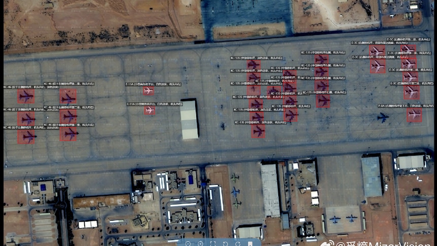
MizarVision, a geospatial artificial intelligence and software company partly owned by the Chinese government, has been disseminating detailed satellite images coupled with tagging information related to various US military sites, particularly during the lead-up to and throughout the Iran conflict. The technology employed by MizarVision allows for the identification and tagging of military assets over extensive areas—a capability that traditionally required the resources of a national intelligence agency.
The Pentagon has indicated that the Iranian Revolutionary Guard Corps (IRGC) is utilizing these AI-enhanced satellite images to aid in targeting specific locations, according to insights from a US Defense Intelligence Agency (DIA) source. The source described this situation as a troubling example of a Chinese company allegedly providing intelligence through an open-source platform that informs missile and drone targeting strategies, which jeopardizes the safety of American personnel and their allies.
Australia has military personnel stationed in the Middle East, including in the United Arab Emirates, an area that was recently hit by an Iranian missile on March 18. An American government official based in Australia has corroborated this classified assessment.
MizarVision’s software has been employed to pinpoint various military capabilities, including identifying distinct aircraft types, the positioning of naval vessels, and the deployment of air defense systems and radar installations. The bipartisan Select Committee on the Chinese Communist Party in the US Congress has expressed concerns that Chinese intelligence activities pose a threat to American forces engaged in operations against Iran. They stated that companies associated with the Chinese Communist Party are transforming AI into a tool for battlefield surveillance aimed at the US, emphasizing that the risks posed by China’s technological advancements are immediate rather than hypothetical.
In a recent development, Planet Labs, a satellite imaging company, revealed that the US government has requested all satellite imagery providers to refrain from sharing images of the conflict zone indefinitely. A spokesperson from the company mentioned that there are serious concerns regarding Planet’s data being utilized over Iran, as well as an extended risk period for recent imagery.
MizarVision has not responded to multiple inquiries from ABC for comments regarding the issue. The Chinese foreign ministry stated that Chinese companies are required to operate within the bounds of laws and regulations. They claimed that the satellite images released by these companies were sourced from open channels and represent standard market activity. The ministry further criticized the tendency of certain entities to wrongly associate the conflict with China for sensational purposes.
In the period leading up to the Iran war, MizarVision’s focus on US military assets in the region intensified. For instance, the company shared images of Prince Sultan Air Base in Saudi Arabia on its Weibo account, along with analyses highlighting significant assets, at least six times during the week before the conflict commenced. Notably, on February 24, they disclosed images pinpointing the location of Patriot air defense systems at the base, followed by additional images on February 27 showing numerous aircraft, just one day prior to the war’s outbreak. Subsequently, Iranian forces targeted this base, resulting in injuries to a US service member, who later succumbed to their wounds in a medical facility.
Michael Dahm, affiliated with the Security Policy Studies Program at the Elliott School of International Affairs, has not reviewed the DIA’s intelligence but remarked that MizarVision’s long-standing practice of providing free imagery raises suspicions. He noted that businesses typically aim to profit, and a model that gives away products without charge is unfeasible. Dahm suggested that the ongoing free distribution of imagery could indicate hidden financial backing, possibly from the Chinese government or military, aimed at influencing the strategic narrative in a conflict and complicating military deployments.
China has vested interests in Iran, having purchased over 80% of Iran’s exported oil prior to the conflict, which was under international sanctions—approximately 1.38 million barrels per day, constituting around 13.4% of China’s total maritime oil imports.
The DIA source emphasized that the dissemination of tagging data poses a clear threat to US military personnel. They asserted that adversaries, particularly within the IRGC, are monitoring this information, which aids in prioritizing targets for missile and drone operations. Asset-based prioritization refers to the military protocols employed to assess the significance of a target. The source noted that not only were several US bases targeted following the release of this material, but specific capabilities that had been identified also became clear targets.
Dahm further commented on the increasing issue of sensitive satellite imagery publication, noting that the implications could have significant consequences for US military operations.