
The Bureau of Meteorology has announced that Tropical Cyclone Maila has been downgraded to a tropical low as it loses strength while moving toward Australia.
Previously classified as a category five storm, Maila caused significant destruction across parts of the Pacific in recent days.
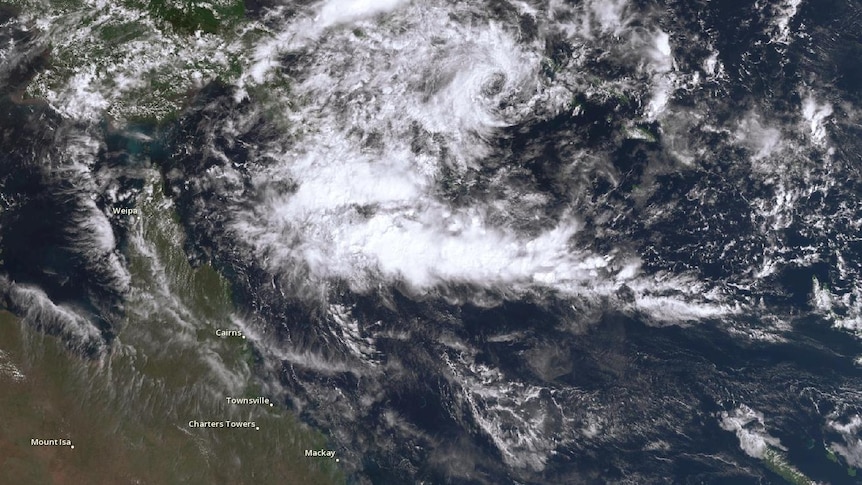
The remnants of the cyclone are expected to traverse the Coral Sea and approach the Far North Queensland coast this week.
This weather system has inflicted severe damage and flooding in Papua New Guinea, but forecasts suggest it will continue to weaken as it approaches the Australian shoreline.
While parts of Queensland are starting to experience cooler autumn temperatures, meteorologists caution that another cyclone could still form this season.
Tropical Cyclone Maila, which reached its peak intensity as a category five system on Friday, is now transitioning into a tropical low as it progresses westward from the Solomon Sea.
During its peak, the cyclone was a powerful force, resulting in widespread destruction, massive waves, storm surges, and landslides in the Pacific region.
The Bureau of Meteorology predicts that by the time it enters Australian waters, the system will be considerably weakened, with landfall expected on Queensland’s Cape York Peninsula by Wednesday.
Senior forecaster Felim Hanniffy noted that while the cyclone is losing strength, the potential for flash flooding and rising river levels remains a concern.
“The critical concern will be the possibility of heavy rainfall once it makes landfall along the Queensland coast,” he stated, emphasizing that many affected areas are still saturated from previous heavy rains.
Hanniffy also mentioned that even though it is late in the cyclone season, the formation of new tropical systems cannot be completely dismissed.
“The sea temperatures are still relatively warm,” he remarked. “Thus, while we are nearing the end of the season, I wouldn’t rule out the emergence of another tropical system later in the year, especially considering the active season we’ve had so far.”
In addition to monitoring the diminishing cyclone, he indicated that Queensland’s coastal and southern regions should prepare for cooler weather at the start of the week.
“Temperatures are expected to drop slightly below average,” he explained, noting that frost could be seen on the Granite Belt by Monday morning.
However, this brief cool spell will not last, as warmer conditions are anticipated later in the week.
“The beginning of this week will provide some relief from the heat, particularly after a warm start to April,” he said, adding that temperatures in southern Queensland will rise again towards the end of the week, though likely not to the same levels as recently experienced.