
A torpedo-like apparatus was uncovered by a fisherman last week in the Lombok Strait, a vital maritime route that connects Australia to the South China Sea.
This device has been determined to be a Chinese undersea monitoring system, intended to be anchored to the ocean floor while transmitting data to remote locations via surface communication buoys.
In response to the discovery, Beijing has downplayed any potential concerns, while Indonesian authorities are continuing their investigation into the device.
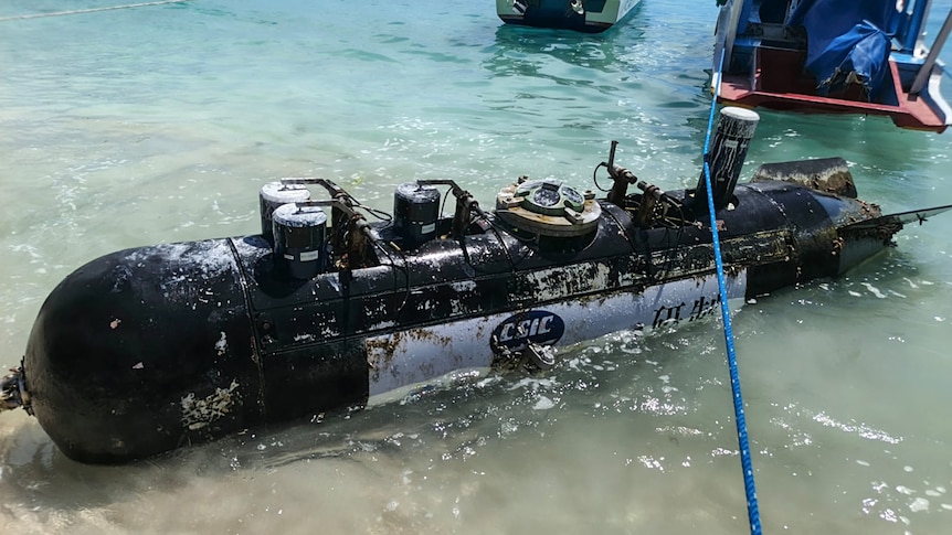
Defense analysts have confirmed that the object, measuring 3.7 meters in length, was located north of Gili Trawangan island within the Lombok Strait, as reported by Indonesia’s state news agency Antara.
The Indonesian Navy has transported the device to their naval base in Mataram, Lombok, for a thorough examination. Rear Admiral Tunggul, a spokesperson for the Navy, stated, “The navy will conduct an extensive investigation to ascertain the device’s origin, function, and any data it may contain.”
Maritime defense expert HI Sutton identified the device as a Deep-Sea Real-Time Transmission Mooring System, developed by the Chinese 710 Research Institute, which specializes in underwater combat technologies.
According to Sutton, the system is designed to be anchored to the seabed and is capable of monitoring various environmental factors, such as temperature, depth, current, and “acoustic and target information.”
While the capabilities of such systems are not exclusive to China, with similar technologies utilized by nations like the United States, Japan, and India, Sutton suggests that the presence of a Chinese sensor buoy could raise concerns among Indonesian officials due to its potential military applications.
He noted that the device’s existence could imply that China maintains a network of sensors that delivers real-time data on underwater conditions in strategically significant waterways, which could enhance their submarine operations.
The 710 Research Institute was part of the state-owned China Shipbuilding Industry Corporation (CSIC), which has now merged into the China State Shipbuilding Corporation (CSSC). The device displayed markings indicating the CSIC and its logo.
Inquiries sent to the CSSC by the ABC received no response, and a spokesperson from the Chinese Ministry of Foreign Affairs stated they were unable to provide specific details on the incident. However, the spokesperson emphasized that China has always engaged in marine scientific research in compliance with international law and that it is not uncommon for marine research devices to accidentally drift into other nations’ territorial waters.
Collin Koh, a maritime security expert, commented on the device’s sensor capabilities combined with its communication abilities, suggesting it could serve purposes related to undersea warfare. He noted, however, that the data collected could also be beneficial for civilian applications.
“This dual-use nature of technologies related to marine research and data collection often presents challenges,” said Dr. Koh, who is a senior fellow at the S. Rajaratnam School of International Studies in Singapore. He pointed out that China has been engaged in seabed mapping in the region, frequently collaborating with Southeast Asian countries.
Dr. Koh acknowledged that while several Chinese underwater drones have been found by Indonesian fishermen in the past few years, this incident marks the first instance of a moored sensor buoy being detected in the area. He indicated that this aligns with China’s increasing focus on Indonesia’s territorial waters and archipelagic sea routes, especially in light of Australia’s AUKUS agreement with the United States and the United Kingdom regarding nuclear-powered submarines.
Malcolm Davis, a senior analyst at the Australian Strategic Policy Institute, suggested that Beijing understands the significance of mapping the maritime landscape in the Indonesian archipelago for potential undersea warfare scenarios. “My assessment is that a Chinese vessel or submarine deployed this device to monitor submarine movements in that specific area,” he stated. “Their aim seems to be to track submarines to position themselves advantageously in case of conflict.”
The Lombok Strait serves as a crucial economic and military passage between the Indian and Pacific Oceans. With depths reaching a minimum of 250 meters and narrowing to 18 kilometers at its tightest point, it is a vital route for vessels with deep drafts that cannot navigate through the Malacca Strait, making it a potential alternative should the Malacca Strait become inaccessible.
Dr. Koh emphasized that the Lombok Strait is also critical for the movement of Australian military forces or allied troops stationed in Australia as they transit through Southeast Asian waters toward the South China Sea and potential flashpoints like Taiwan. “Therefore, this strait holds significant strategic importance for Australia,” he remarked.
The legality of the device’s operation under maritime law remains a complex issue, as noted by a doctoral researcher at the University of New South Wales.